 |
| Green River Bridge and Falls, Guilford, Vermont |
There are just TOO many red barns in New England and not enough space in my aging brain to keep track of all of their locations. For that reason I have been forced to be compulsive about labeling my images with their GPS locations. Over the years, I've used a number of different techniques, but I'm happiest with my current approach which depends on the amazing power of the Lightroom Map Module. If you don't have Lightroom or haven't used the Map Module to its full potential, consider this your wake-up call.
Past History
I started recording GPS coordinates using a separate GPS logger and special software to synchronize the images based on the time they were taken. It worked reasonably well, but added several, often time consuming, steps to my work-flow. A few
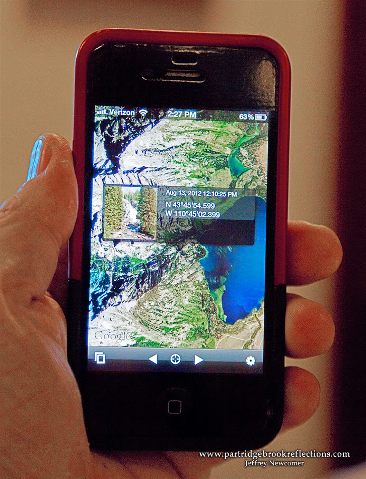 years ago, while on a trip to Yellowstone and the Tetons, I misplaced my small logger and, of necessity, began using my iPhone to capture GPS labeled images in key locations. I would then manually add the coordinates to the metadata of the images taken in those spots. I just needed to remember to grab the iPhone picture in each location. All this was a bit complicated, but it worked, as long as I stayed rigorous in my work-flow. Then I finally broke down and got Lightroom 5 and everything changed.
I purchased Lightroom primarily to simplify the organization and accessibility of my hundreds of thousands of image files, but in a short time I found myself using it to streamline file uploading and to do the majority of my editing, finishing the process in Photoshop. Since Lightroom 4 the program has also included a nifty Map Module which makes it much more intuitive and easy to add and use GPS Coordinates in your images. Here's how it works.
Finding Yourself
Upon return from a photo shoot I usually have a good idea about
.jpg) the locations of most of my images, especially when my shots are close to home. The Map Module portrays a Goggle Map in the display. It does require that the program has a connection to the internet to allow access to Google Maps, but then it is easy to click and drag groups of images to their known locations on the map. Immediately the images are labeled with their coordinates and a small tag (or "Pin") appears on the map including the number of
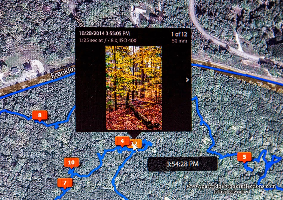
the locations of most of my images, especially when my shots are close to home. The Map Module portrays a Goggle Map in the display. It does require that the program has a connection to the internet to allow access to Google Maps, but then it is easy to click and drag groups of images to their known locations on the map. Immediately the images are labeled with their coordinates and a small tag (or "Pin") appears on the map including the number of 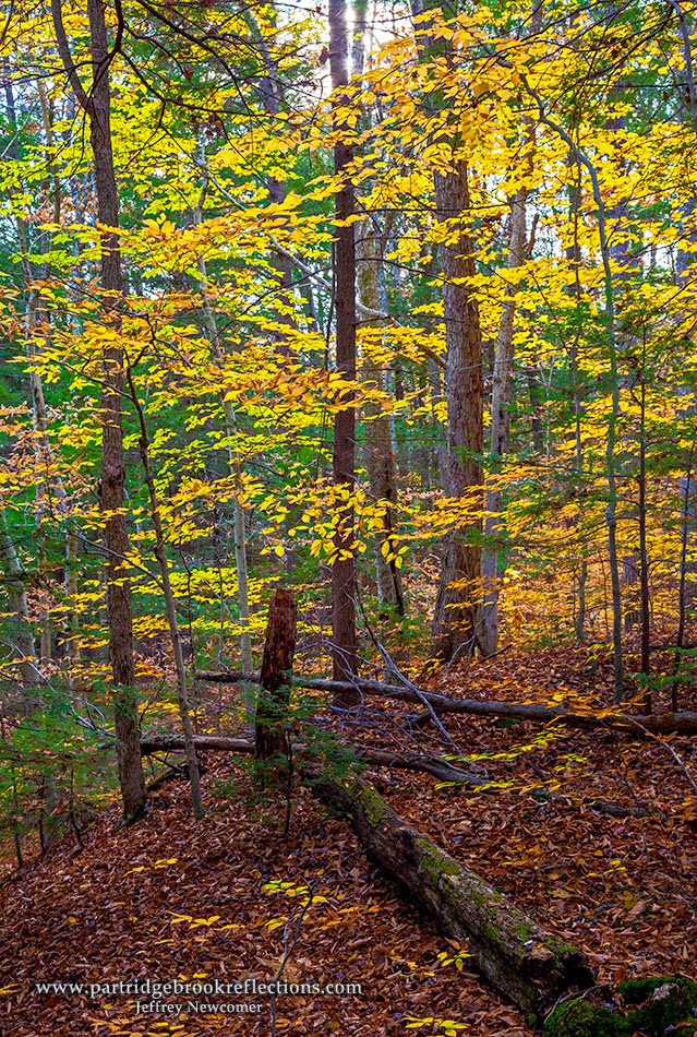 images placed in that location. Hovering the cursor over the tag reveals a thumbnail showing the top image from that spot and an arrow allows scrolling through all of the other images in the stack. I'm usually able to place tags for familiar locations within a couple of minutes. I can drag the map for nearby spots or use the search box to jump to more distant locations. I still use my iPhone images to fix less familiar locations, and I can find them on the map by typing the GPS Coordinates into the search box. I just need to remember to put the negative sign in front of the longitude coordinates to avoid ending up in Kyrgyzstan.
  | ||
| Ancient Red Oak in Friedsam Forest |
Randon Aside
Actually if you dig straight through the earth from New Hampshire you don't end up in Kyrgystan or, as tradition would suggest, China, but actually in the southern Indian Ocean north of the isolated French island of Kerguelen. There!, you must admit that you have learned something from this post.
The Map Module provides a fun way to quickly see where you have traveled on your photography shoots and quickly preview the images taken in any area.
 |
| Pins marking nearly 60 thousands images in the Monadnock Region |
Tracking
 |
| A Hike in Friedsam Town Forest |
 |
| Forgotten Wall, Friedsam Forest |
 |
| Friedsam Town Forest, Chesterfield, NH (pin # 8) |
Putting the Data to Work
 |
| Spofford Lake & Harvey Pond |

 |
| Map Location Icon |
Zooming the map out to include much of Cheshire County, you can see that I have taken more than just a few images in my home region, nearly 60,000. Tags with a pointer refer to a single location and rectangular tags indicate that more than one location is under
 |
| Harvey Pond with resolved locations |
 |
| "Location" including Cheshire County |
 |
| Filtering for the Cheshire County Location |
 |
| Red BarnSearch |
Lightroom is a remarkably capable program with more features than I can sensibly be expected to understand, but much like Photoshop, it is a constant adventure finding new toys to help me manage and fulfill the potential of my images. And now I DO know where that red barn is.
 |
| The Red Barn, Windsor, Vermont |
Julieanne Kost of Adobe TV has an excellent video describing the features of the Lightroom Map Module.
Jeffrey Newcomer
partridgebrookreflections.com
Great post. My Canon 6D has GPS but since it tends to drain the battery I don't usually have it on. But maybe I should reconsider.
ReplyDelete