
 |
| The Full Crash |
Capturing the Crash : Surf Stacking
I don't get to the shore as often as I would like. Those
of us who live around Keene New Hampshire are proud of announcing that we are
located in the “precise geographic  center of New England”, but that does mean
that I must make a long trek to get to the ocean. I grew up on the north
shore of Boston and spent my summers on the water in Gloucester Massachusetts.
I love living in the Monadnock region but my distance from the shore is
my only major regret, so, whenever I get the chance, I bring my camera to
capture the restless water. From my sadly limited experience, I can't
claim to be an expert on ocean surf photography, but, since I seldom can wait for
the perfect conditions, I have learned something about making the best of the
conditions with which I am presented.
center of New England”, but that does mean
that I must make a long trek to get to the ocean. I grew up on the north
shore of Boston and spent my summers on the water in Gloucester Massachusetts.
I love living in the Monadnock region but my distance from the shore is
my only major regret, so, whenever I get the chance, I bring my camera to
capture the restless water. From my sadly limited experience, I can't
claim to be an expert on ocean surf photography, but, since I seldom can wait for
the perfect conditions, I have learned something about making the best of the
conditions with which I am presented.
 center of New England”, but that does mean
that I must make a long trek to get to the ocean. I grew up on the north
shore of Boston and spent my summers on the water in Gloucester Massachusetts.
I love living in the Monadnock region but my distance from the shore is
my only major regret, so, whenever I get the chance, I bring my camera to
capture the restless water. From my sadly limited experience, I can't
claim to be an expert on ocean surf photography, but, since I seldom can wait for
the perfect conditions, I have learned something about making the best of the
conditions with which I am presented.
center of New England”, but that does mean
that I must make a long trek to get to the ocean. I grew up on the north
shore of Boston and spent my summers on the water in Gloucester Massachusetts.
I love living in the Monadnock region but my distance from the shore is
my only major regret, so, whenever I get the chance, I bring my camera to
capture the restless water. From my sadly limited experience, I can't
claim to be an expert on ocean surf photography, but, since I seldom can wait for
the perfect conditions, I have learned something about making the best of the
conditions with which I am presented. Last weekend Susan I traveled to visit old friends who are now
living in York Maine. We were excited to spend time with Wally and Michele
and even more excited to see their new granddaughter Maya and her doting
parents, Emile and Keri. Of course I also had my eye on the weather and
tides to see what I might capture by sneaking away to the shore. York's
premiere coastal attraction is the classic Nubble Lighthouse perched
dramatically on its tiny island off Cape Neddick. I've shot the
lighthouse many times but I am always looking for new light and angles.
On this trip I had to work a little harder.
Last weekend Susan I traveled to visit old friends who are now
living in York Maine. We were excited to spend time with Wally and Michele
and even more excited to see their new granddaughter Maya and her doting
parents, Emile and Keri. Of course I also had my eye on the weather and
tides to see what I might capture by sneaking away to the shore. York's
premiere coastal attraction is the classic Nubble Lighthouse perched
dramatically on its tiny island off Cape Neddick. I've shot the
lighthouse many times but I am always looking for new light and angles.
On this trip I had to work a little harder.  |
| Nubble Light, A Better Dawn |
I initially planned to get up early on Sunday for sunrise at the light, but, as I went to bed, my iPad showed me that the morning was predicted to heavily overcast. No chance for a glorious sunrise and besides the tide would be nearly dead low at dawn. There seemed nothing to be gained from dragging myself out of bed at 4AM. I only half reluctantly turned off my alarm and settled in for a nice long rest. My next option was to get up for a leisurely breakfast with friends and then see how things looked at around noon when the tide would be high and perhaps there would be a few breaks in the clouds.
Of course even on an overcast day Nubble Light is a popular
tourist attraction and the dense noontime crowd was assembled on our arrival.
Fortunately, the tourist thin substantially down on the slippery rocks
and I was able to find a number of unobstructed angle to the lighthouse.
The decent was a bit scary considering my crumby left hip, which is scheduled
for replacement next month, but I made it down without damage to either my joints
or, more importantly, to my gear.
 I hoped for energetic surf from the passing storm, but
the waves were only moderate. I scouted for locations with interesting
foreground rocks and a good angle on the light, and then the trick was to
get low on the rocks to minimize the apparent gap between the shore and the
island. I settled in and, as my butt became progressively cold and damp,
I planned the shots I would need to capture the full drama of the crashing
surf.
I hoped for energetic surf from the passing storm, but
the waves were only moderate. I scouted for locations with interesting
foreground rocks and a good angle on the light, and then the trick was to
get low on the rocks to minimize the apparent gap between the shore and the
island. I settled in and, as my butt became progressively cold and damp,
I planned the shots I would need to capture the full drama of the crashing
surf.
The challenge of surf photography comes as we try to capture
the sense of relentless motion within the limitations of a still image.
Here are the problems, and some of my attempts at solutions.
Surf in Motion
 |
| Newport Dawn, 1/250th f18 |
The portrayal of surf varies widely primarily based on the
length of the shutter. Short exposures freeze the drops in mid-flight
highlighting the hectic, random nature of the splash, but I love long exposures
that render the water in a soft blur that portrays a sense of motion.
 |
| Portland Light Surf, 1/4 f22 |
For these images the timing can be quit
critical. With longer exposures the detail in the water can be lost and
with exposures of several seconds the churning ocean can be rendered as a misty
flat pool. It is all a matter of artistic taste, but, in most situations,
I prefer shutters set to less than a second to preserve enough detail in the
water to reflect the patterns in the flow.
 |
| Penobscot Mist , 2 Seconds f22 Flattens the Waves |
Capturing the Right Wave
 |
| Wave Patterns |
 |
| Pemaquid Light, One of 35, 1/6th f22 |
photography and large
memory cards. Years ago I was shooting the surf off of Pemaquid Light in Maine
from a precarious rock which projected into the bay. Before I was nearly washed
away I managed to capture more than seventy images, as I tried to anticipate
the perfect wave. At home I was thrilled to find two images from the 70
that I felt were worthy "keepers".
One is thirty-five is not a bad ratio.
Getting Depth
I usually try to include interesting foreground rocks in my surf
and lighthouse images and, even with the small apertures dictated by my long
exposures, it is often impossible to capture the full depth of field in focus.
I routinely use focus stacking to get everything sharp but the foreground
surf has a tendency to get in the way.
 |
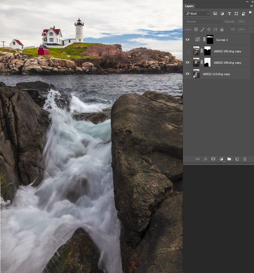
| Getting the Full Crash |
On a number of the photographs of
Nubble Light, I first shot a series of images focused on various planes,
restricting my shots to times when the surf was quiet. I combined these in
a “Focus Stack” using Photoshop's Auto Align and Auto Blend tools and used this
blend as my baseline full focus image. I then settled back, focused on
the foreground rocks, and shot multiple images of the crashing surf trying to
capture the perfect wave and its aftermath. In post I was able to choose
among my best surf shots to blend with my baseline depth of field image.
Cool huh? Cheating? Of course not it was what I saw - almost
- there is still one more step to blend the entire experience into a single
image.
Capturing the Whole Event : Surf Stacking
 |
| After the Storm , Kennebunkport Maine |
When I watch a wave crashing against the rocks the full
dramatic event usually takes a second or two from the initial explosion of surf
through the secondary surge of froth blanketing the rocks. It is much
like fireworks whose initial explosion is followed by the flowering of colored
streamers. For both fireworks and crashing surf, my eye records the event
as an unbroken continuum, but, given my desired shutter speed, a single still
photograph of surf can only record a portion of the display.
 |
| Three Part Splash |
Returning to the crash, I blended parts of three shots taken to record the progression of the wave's “performance”.
The first shot captured the splash at its peak but tended to wipe out the view of the rocks further in. The second and third shots combined to show the surf working its way around the rocks revealing subtler patterns of dark and light. Using the blend of the three shots, I was able to much more closely match, in a single digital image, what my miraculous "analog" eye perceived.
Shooting the Slot
 I finished by settling into a somewhat precarious position along the
slippery edge of a slot that faced the lighthouse. Again, a burst of
images recording a single wave includes views of initial splash along with the
rushing swirl that shot up the slot. I just had to remember to lift my
feet with each surge. No single image
recorded the full cascading event but a blend of three images was much truer to
what was dramatically apparent to the eye. I then added this surf blend
to a background image which was captured to get the lighthouse in sharp focus.
I finished by settling into a somewhat precarious position along the
slippery edge of a slot that faced the lighthouse. Again, a burst of
images recording a single wave includes views of initial splash along with the
rushing swirl that shot up the slot. I just had to remember to lift my
feet with each surge. No single image
recorded the full cascading event but a blend of three images was much truer to
what was dramatically apparent to the eye. I then added this surf blend
to a background image which was captured to get the lighthouse in sharp focus. |
| The Slot |
The Purist Lament
Ok, while you are busy being appalled with all my trickery and
before you say that I was not recording the actual experience, I would argue
that the least accurate representation of crashing surf would be a single image
freezing only a short segment of the event. Whether or not you agree
there is one more point me can all acknowledge.
Don't Get Washed Out to Sea
 |
| Almost Stranded Off Hampton Beach NH |

I hope that you will find better conditions on your next trip to the shore. The best opportunities generally come at high tide after a big storm has kicked up massive breakers, but with a little planning you should be able to make the most out of whatever nature provides. The waves are giving their all to the performance, the least you can do is work to bring it all home.
Jeffrey Newcomer


